Category:
BrowseNode:
Language:
Currency:
Output:
Display of "Out of Stock" :
Sorting:
Extraction:
Search Setting [Setting URL (List without Keyword): https://lead.to/amazon/com/?key=*&la=pt&bn=17255]
Keyword: * ( List without Keyword)
Market:
Category: All
BrowseNode: 17255
Language: Portuguese
Currency: USD (United States Dollar)
Output: Normal Output
Display of "Out of Stock" : OFF
Sorting: Relevance
Extraction: Not Specified
Displayed Page : 6 (51st to 60th)

Frommer's Yellowstone and Grand Teton National Parks (Complete Guide)

Capa comum FrommerMedia Kwak-Hefferan, Elisabeth Kwak-Hefferan [author]
[Guias de Excursão para Trilha e Acampamento
Release Date: 2023-03-28 Number of Pages: 254 ASIN/ISBN-10:
Price: US$ 14,99
[

Fodor's The Complete Guide to Alaska Cruises (Full-color Travel Guide)

Capa comum Fodor's Travel Fodor's Travel Guides [author]
[Rafting
Release Date: 2022-04-12 Number of Pages: 384 ASIN/ISBN-10:
Price: US$ 16,28
[


Washington Bucket List: Set Off on 150 Epic Adventures and Discover Incredible Destinations to Live Out Your Dreams While Creating Unforgettable Memories that Will Last a Lifetime. (Map Included)


Capa comum Independently published Travel, BeCrePress [author]
[Livros de Viagens da Costa Oeste dos Estados Unidos
Release Date: 2023-09-29 Number of Pages: 130 ASIN:
Price: US$ 16,90
[

Fodor's Oregon (Full-color Travel Guide)

Capa comum Fodor's Travel Fodor's Travel Guides [author]
[Viagem Geral para Austrália e Pacífico Sul
Release Date: 2023-06-13 Number of Pages: 384 ASIN/ISBN-10:
Price: US$ 12,84
[


What NOT To Do - Hawaii (A Unique Travel Guide) (What NOT To Do - Travel Guides)


Capa comum Specter Publication LLC Brekenridge, Sarah [author]
[Livros de Viagens da Costa Oeste dos Estados Unidos
Release Date: 2024-03-18 Number of Pages: 129 ASIN/ISBN-10:
Price: US$ 16,99
[
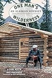
One Man's Wilderness, 50th Anniversary Edition: An Alaskan Odyssey

Capa comum Alaska Northwest Books Proenneke, Richard Louis [author], Keith, Sam [author]
[MemóriasbBiografias
Release Date: 2018-09-11 Number of Pages: 272 ASIN/ISBN-10:
Price: US$ 16,90
[

Rand McNally Easy to Read Folded Map: Idaho State Map

Mapa Rand McNally Rand McNally [author]
[Atlas
Release Date: 2021-08-06 Number of Pages: 1 ASIN/ISBN-10:
Price: US$ 7,99
[
Regularly updated, full-color maps
128% larger map with a bigger type size than the Rand McNally Folded Map
Clearly labeled Interstate, U.S., state, and county highways
Indications of parks, points of interest, airports, county boundaries, and more
Mileage and driving times map
Detailed index
Convenient folded size
Copyright 2022


Fodor's San Diego (Full-color Travel Guide)


Capa comum Fodor's Travel Fodor's Travel Guides [author]
[Destinos Turísticos e Museus Viagem
Release Date: 2023-10-31 Number of Pages: 288 ASIN/ISBN-10:
Price: US$ 17,60
[

The Indifferent Stars Above: The Harrowing Saga of the Donner Party

Capa comum Mariner Books Brown, Daniel James [author]
[Biografias Mulheres
Release Date: 2015-09-22 Number of Pages: 384 ASIN/ISBN-10:
Price: US$ 10,79
[

Wildflowers of Colorado Field Guide (Wildflower Identification Guides)

Capa comum Adventure Publications Mammoser, Don [author], Tekiela, Stan [author]
[Jardinagem da Região Leste
Release Date: 2022-07-26 Number of Pages: 432 ASIN/ISBN-10:
Price: US$ 13,60
[
Simplified Setting and Result Count
Keyword: * ( List without Keyword)
Category: All
BrowseNode: 17255
Display of "Out of Stock" : OFF
Extraction: Not Specified
Result Count: More than 100 hits
Sorting: Relevance
Displayed Page : 6 (51st to 60th)